Jet streams driving surge in western disturbances in northwest India| India News
Unusual Weather Patterns Grip Northwest India Jet Streams Drive Surge in Western Disturbances
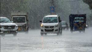
Northwest India experienced an unprecedented surge in Western Disturbances (WDs) this March, bringing unseasonal weather and significant concern. Against a typical five to six WDs, March recorded eight. Meteorologists anticipate at least three more through mid-April, signaling sustained unusual atmospheric activity. This heightened frequency stems largely from shifts in powerful high-altitude air currents: jet streams.
To clarify, imagine jet streams as fast, high-altitude rivers of air steering global weather systems. A Western Disturbance is a weather system from the Mediterranean region, carrying moisture eastward. When jet streams alter their usual path, they can direct more or intensified WDs towards India’s northern plains, disrupting established patterns.
This abnormal weather has led to widespread unseasonal rainfall and hailstorms across Punjab, Haryana, Rajasthan, Himachal Pradesh, and Jammu & Kashmir. Local reports confirm extensive damage to standing Rabi crops like wheat and mustard, critically impacting agricultural livelihoods as harvest nears. Farmers face significant losses. The India Meteorological Department (IMD) provides essential forecasts.
Beyond agriculture, these disturbances cause erratic temperature fluctuations, prolonging summer’s arrival. While moisture benefits some regions, the timing and intensity disrupt natural cycles. Omni 360 News tracks these developments. Understanding complex atmospheric interactions, especially jet stream influence, is paramount for climate adaptation.
Key Takeaways:
March saw eight WDs, exceeding the norm; three more expected by mid-April. Shifting jet streams are the primary cause. Rabi crops in northwest India suffer from unseasonal rain and hail, leading to farmer losses. Temperatures remain unstable, delaying summer.