Inspection begins for relocation of disaster-hit families from Uttarkashi’s Dharali| India News
Land Inspections Underway for Affected Families Key Takeaways from Geologist Pradeep Kumar’s Team
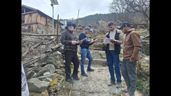
In a crucial step towards addressing land-related concerns, Assistant Geologist Pradeep Kumar has confirmed that his team has successfully completed field inspections of land parcels identified by 30 affected families. This marks the culmination of the first phase in a larger, ongoing process, signaling progress in evaluating land suitability and addressing community needs. This initiative, often seen in local news reporting, is a cornerstone of responsible development and disaster rehabilitation, ensuring that expert geological assessment forms the bedrock of decision-making.
The inspections, spearheaded by Mr. Kumar’s team, involve a meticulous examination of designated land areas. For the 30 families whose parcels were assessed in this initial phase, the inspections represent a significant moment. These families often face displacement or the need for relocation due to various reasons, such as major infrastructure projects—like new roads, industrial zones, or irrigation schemes—or the aftermath of natural events, including landslides or severe flooding, making their current homes unsafe. The phrase “affected families” itself speaks volumes about the disruption to their lives, underscoring the human element at the heart of these technical assessments.
Understanding the Geologist’s Role
So, what exactly does an Assistant Geologist like Pradeep Kumar and his team look for during these field inspections? Imagine a big construction project needs land, or perhaps an entire village needs to move because their current location is unsafe. Before any decisions are made, experts must check the ground itself. Geologists are like the detectives of the Earth, studying its composition, structure, and processes.
During these inspections, the team assesses several critical factors:
* Soil Stability: Is the soil strong enough to support new structures? Or is it prone to erosion, liquefaction (where solid ground turns to a liquid-like state during an earthquake), or subsidence (sinking)?
* Water Drainage: How does water flow across and through the land? Is it prone to waterlogging, or are there underlying water sources that could affect construction or agriculture?
* Geological Hazards: Are there any fault lines, potential for landslides, rockfalls, or sinkholes? Understanding these risks is vital for the long-term safety of any proposed development or resettlement site.
* Suitability for Use: Based on the above, is the land suitable for residential buildings, agriculture, or specific industrial purposes? For instance, land prone to flooding wouldn’t be ideal for homes, just as rocky terrain might not be suitable for farming.
* Environmental Impact: The team also considers potential environmental impacts, such as groundwater contamination risks or disruption to local ecosystems.
For the affected families, these inspections are not merely technical exercises. They are a critical part of determining their future. The findings will directly influence compensation values, the selection of alternative resettlement sites, or the viability of remaining in their current locations after mitigation measures. This is why the precision and transparency of such assessments are paramount, forming the basis of fair dealings and sustainable solutions.
The Human Dimension of Land Assessment
Local communities often watch these processes unfold with a mixture of hope and apprehension. Hope for fair compensation, safe new homes, and a secure future. Apprehension about the unknown, the disruption to their way of life, and the potential for bureaucratic delays. The involvement of 30 families in this first phase suggests a carefully managed approach, beginning with a manageable number before scaling up. This phased methodology allows for refinement of the process and ensures individual cases receive due attention.
Local news outlets frequently highlight stories from communities undergoing such changes, bringing to light the personal narratives behind the land parcels. These are not just plots of earth; they are homes, livelihoods, and ancestral connections. A seasoned journalist understands the importance of conveying this human perspective alongside the technical details, making the news relevant and relatable.
What Comes Next
Following the completion of these initial field inspections, the work of Assistant Geologist Pradeep Kumar’s team now moves to the analysis phase. Data collected from the field—soil samples, topographical surveys, and visual observations—will be meticulously analyzed in laboratories and offices. Reports will be generated, detailing the geological characteristics of each parcel and offering recommendations.
These reports will then typically be shared with relevant government agencies, local planning bodies, and, importantly, the affected families themselves. This engagement is crucial for building trust and ensuring that decisions are made transparently. Future phases will likely involve further inspections for additional families, public consultations, and the implementation of resettlement or compensation plans based on these geological findings.
The integrity of this process, from initial inspection to final resolution, hinges on the unbiased and expert work of professionals like Assistant Geologist Pradeep Kumar. Their efforts ensure that development projects are built on solid ground—both literally and figuratively—and that the well-being of affected communities remains a central consideration. Omni 360 News believes in comprehensive reporting that connects the technical aspects of such work with its profound human impact, offering a complete picture to our readers.
Key Takeaways:
* Assistant Geologist Pradeep Kumar’s team has completed crucial field inspections for 30 affected families, marking the first phase of a significant land assessment process.
* These geological inspections evaluate soil stability, drainage, and potential hazards to determine land suitability for resettlement or development.
* The findings directly impact decisions regarding compensation, relocation sites, and community safety.
* The process is vital for ensuring fair and sustainable outcomes for communities facing displacement or land-related challenges.
* Transparency and expert analysis are critical to building trust and addressing the human impact on affected families.