2026’s First Category 5 Super Cyclone "Horacio"
Port Louis, Mauritius – In a terrifying display of nature’s raw power, the South Indian Ocean has birthed its first “monster” of the year. Cyclone Horacio has undergone a staggering transformation, exploding from a manageable storm into a Category 5 Super Cyclone in less than 24 hours. With wind speeds screaming at 260 kilometers per hour, this massive weather system has put meteorologists on high alert and sent a ripple of anxiety across the region.
From Calm to Catastrophic in Hours
What makes Horacio particularly chilling is how fast it grew. On the Saffir-Simpson scale the gold standard for measuring hurricane strength, Horacio has officially hit the highest possible tier. Just a day ago, it was a developing system; today, it is a “beast” with a symmetrical, cloud-free eye that signifies a perfectly organized engine of destruction.
According to latest reports from the Joint Typhoon Warning Center (JTWC), the storm’s rapid intensification was fueled by exceptionally warm ocean waters, hovering around 28°C. These warm waters act like high-octane fuel for cyclones, allowing them to suck up energy and spin with lethal velocity.
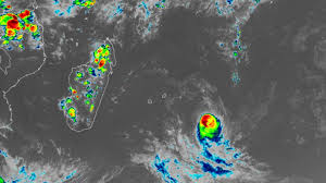
The Current Situation: Who Is at Risk?
The good news is that, for now, the heart of the storm remains over open water. However, the “reach” of a Category 5 storm is massive.
- Rodrigues Island: Residents have already experienced gusts of up to 100 km/h and massive sea swells reaching 7 meters.
- Mauritius: While the main island has avoided a direct hit, the Mauritius Meteorological Services (MMS) have been monitoring the system closely, issuing warnings for heavy swells and dangerous maritime conditions.
- Marine Interests: Shipping lanes in the South Indian Ocean are effectively on lockdown near the storm’s path, as waves near the center are estimated to be over 12 meters high.
The Climate Connection
Scientists at Omni 360 News note that while cyclones are a seasonal reality, the frequency of “Rapid Intensification”—where a storm’s winds increase by at least 55 kmph in 24 hours is becoming a signature of our warming planet. Horacio didn’t just meet that threshold; it nearly tripled it.
What Happens Next?
The latest satellite data suggests Horacio may have reached its peak. As it moves further south into cooler waters and encounters stronger crosswinds (wind shear), the “eye” is expected to cloud over and the storm will begin to lose its punch. However, the legacy of Horacio will remain as a stark reminder of how quickly the ocean can turn into a battlefield.