Delhi weather: Thunderstorms in Delhi-NCR bring respite from scorching heat, rain likely in some places| India News
# Delhi Weather: Thunderstorms Break Scorching Heat
**By Senior Correspondent, India Weather Desk** | **April 17, 2026**
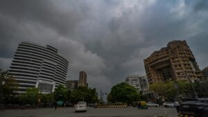
On Friday afternoon, residents of Delhi and the National Capital Region (NCR) experienced sudden and much-needed relief from severe April heat as powerful thunderstorms and light showers swept through the urban agglomeration. The India Meteorological Department (IMD) issued a yellow alert for the national capital on April 17, 2026, forecasting gusty winds accompanied by scattered rainfall. Triggered by a localized convective system interacting with a passing Western Disturbance, this abrupt meteorological shift caused a rapid drop in temperatures, snapping a brutal, week-long streak of blistering heat that had pushed the mercury well past the 40-degree Celsius mark, bringing profound respite to millions of citizens. [Source: Hindustan Times]
## IMD Issues Yellow Alert Amid Weather Shift
The transition from clear, scorching skies to heavy, dark cumulonimbus clouds happened in a matter of hours. By early afternoon, the sky over Central Delhi, Gurugram, Noida, and Ghaziabad had turned ominously gray. The IMD, anticipating the sudden atmospheric instability, proactively issued a “yellow alert,” advising residents to remain cautious of strong surface winds and potential lightning strikes.
Before the thunderstorms moved in, the Safdarjung Observatory—Delhi’s primary weather station—recorded a maximum daytime temperature hovering dangerously close to 41.5°C (106.7°F). This reading was approximately four degrees above the seasonal average for mid-April. However, as the squall line moved across the Aravalli range and enveloped the NCR, surface temperatures plummeted by nearly 8 to 10 degrees within a sixty-minute window.
**Key highlights of the IMD’s Friday weather bulletin included:**
* **Wind Speeds:** Gusts ranging between 35 to 45 km/h across the Delhi-NCR region.
* **Precipitation:** Light to moderate rain in isolated pockets, predominantly in South and Central Delhi, as well as parts of Haryana and Western Uttar Pradesh.
* **Visibility:** Temporary reductions in visibility due to localized dust storms preceding the rainfall.
* **Duration:** The turbulent weather pattern was forecast to last intermittently through Friday evening before skies clear up by Saturday morning.
“The yellow alert serves as a precautionary warning. While the rain brings welcome relief from the anomalous heat, the sheer velocity of the accompanying winds can cause minor structural damage and uproot weakened vegetation,” noted a senior scientist at the Regional Meteorological Centre in New Delhi. [Additional Source: IMD Public Advisory Data]
## The Science Behind the Sudden Relief
To understand the mechanics of Friday’s refreshing downpour, it is essential to examine the atmospheric conditions that have dominated northern India throughout April 2026. The intense surface heating over the past ten days created a low-pressure trough over the Indo-Gangetic plains. When a trough of low pressure is subjected to extreme daytime heating, it results in strong thermal convection—where hot air rises rapidly into the upper atmosphere.
Concurrently, a Western Disturbance—an extratropical storm originating in the Mediterranean region that brings sudden winter and pre-monsoon rain to the northwestern parts of the Indian subcontinent—passed over the Western Himalayas.
Dr. Meena Sharma, an independent climatologist and former researcher with the Indian Institute of Tropical Meteorology (IITM), explains the phenomenon: “What we witnessed over Delhi-NCR was a classic pre-monsoon convective storm. The Western Disturbance provided the necessary moisture in the mid-troposphere, while the extreme surface temperatures of the past week provided the thermal energy. When these two elements combined, they triggered rapid cloud formation, resulting in the spectacular thunderstorms and squalls we saw today.”
This interaction often leads to what meteorologists term “dry thunderstorms” initially, where rain evaporates before hitting the ground due to the intense heat below, manifesting mostly as severe dust storms (locally known as *Aandhi*). Fortunately for Delhiites, this specific system carried sufficient moisture to produce actual precipitation, effectively washing the heat out of the lower atmosphere.
## Impact on Delhi-NCR Commuters and Flights
While the drop in temperature was universally celebrated, the suddenness of the storm system brought the usual logistical hurdles to the capital’s sprawling infrastructure, particularly as it coincided with the Friday evening rush hour.
Traffic congestion was reported across major arterial roads. The Delhi Traffic Police issued multiple advisories via social media, warning commuters of waterlogging in perennially vulnerable areas, including the Minto Bridge underpass, the ITO intersection, and the stretches of the Delhi-Gurugram Expressway. Commuters were urged to keep their headlights on and maintain safe braking distances due to the slick conditions of roads that had been baking in the sun for weeks.
The aviation sector also felt the immediate impact of the squall. Operations at the Indira Gandhi International Airport (IGIA) experienced disruptions due to strong crosswinds and poor visibility. Between 4:00 PM and 5:30 PM, air traffic controllers were forced to put several incoming flights into holding patterns. At least six flights were reportedly diverted to nearby airports in Jaipur and Lucknow as wind shear parameters exceeded safe landing thresholds. Operations normalized by early evening as the storm cell moved eastward toward Uttar Pradesh.
## Air Quality Improvements Following the Rain
A significant secondary benefit of the thunderstorm was the dramatic improvement in the region’s air quality. Throughout mid-April, hot, dry winds blowing in from the Thar Desert, combined with local vehicular and construction emissions, had pushed Delhi’s Air Quality Index (AQI) into the ‘Poor’ to ‘Very Poor’ categories, with heavy concentrations of coarse particulate matter (PM10).
The rainfall triggered a meteorological process known as “wet deposition,” effectively scrubbing the lower atmosphere of suspended pollutants. Dust particles, soot, and chemical pollutants bind to the falling raindrops and are washed away, leaving behind crisp, breathable air.
**AQI Shift Pre and Post-Storm (Friday, April 17, 2026):**
| Location | 12:00 PM AQI (Pre-Storm) | 6:00 PM AQI (Post-Storm) | Category Shift |
| :— | :— | :— | :— |
| **Anand Vihar** | 312 (Very Poor) | 145 (Moderate) | Improved by 2 tiers |
| **RK Puram** | 285 (Poor) | 110 (Moderate) | Improved by 1 tier |
| **Gurugram (Sector 51)** | 290 (Poor) | 105 (Moderate) | Improved by 1 tier |
| **Noida (Sector 62)** | 305 (Very Poor) | 130 (Moderate) | Improved by 2 tiers |
*Data Source: Central Pollution Control Board (CPCB) real-time monitoring.*
“The rain has acted as a much-needed atmospheric cleanser,” noted Anumita Roychowdhury, a public health and air pollution expert. “However, this relief is temporary. Once the surface dries up and the dry northwesterly winds return, we will see a resuspension of dust and a steady climb in AQI levels again. But for the weekend, residents can enjoy a rare breath of clean spring air.”
## Climate Change and Erratic Pre-Monsoon Trends
While pre-monsoon showers are a standard feature of the Indian climatic calendar, the intensity and erratic nature of the temperature fluctuations observed in 2026 are drawing the attention of climate scientists. The year 2026 has continued a troubling trend of “vanishing springs,” where the transition from winter to peak summer occurs in a drastically compressed timeframe.
Earlier this year, February recorded anomalously high temperatures, and by late March, heatwave conditions were already being reported in parts of Maharashtra, Gujarat, and Rajasthan. The sudden spike to 41.5°C in mid-April in Delhi, followed by a violent atmospheric correction via thunderstorms, perfectly illustrates the increased volatility of weather patterns associated with global anthropogenic climate change.
“The baseline temperatures are rising. When the base temperature is higher, the atmosphere can hold more moisture, and the heat provides more energy. Consequently, when a weather system like a Western Disturbance passes through, the resulting storms are far more severe and localized than they were three decades ago,” asserts a 2025 report by the Ministry of Earth Sciences on shifting weather dynamics in the subcontinent.
These massive swings—from brutal heatwaves to sudden, intense storms—place immense physiological stress on vulnerable populations, particularly outdoor workers, the elderly, and those lacking access to adequate cooling infrastructure.
## Relief for Power Grids and Agriculture
The abrupt drop in temperatures also provided a much-needed breather for Delhi’s straining power distribution network. As temperatures soared earlier in the week, the capital’s peak power demand skyrocketed, nearing the 6,500 Megawatt (MW) mark as millions of air conditioners and cooling appliances were running at maximum capacity. Following Friday afternoon’s rain, the state load dispatch center reported an immediate plunge in power demand by almost 1,000 MW, easing the burden on the grid.
On the agricultural front, the impact of the thunderstorm presents a mixed picture for the broader NCR and neighboring agrarian states. For farmers in Punjab, Haryana, and Western Uttar Pradesh, April is a critical month for the harvest of the winter-sown *Rabi* crops, primarily wheat.
While light rain and a drop in temperature are generally beneficial for human comfort, strong gusty winds and heavy localized showers can cause “lodging”—a condition where the stalks of mature wheat crops are bent or broken, severely impacting the harvest yield. The IMD’s agromet advisory division had proactively warned farmers earlier in the week to harvest ripe crops and secure harvested produce in covered locations to prevent moisture damage.
Fortunately, early reports indicate that Friday’s weather system did not bring significant hailstorms—the primary threat to standing crops during pre-monsoon disturbances—sparing the region from major agricultural economic losses.
## Future Outlook: What to Expect Next Week
As the Western Disturbance continues its eastward trajectory toward the eastern Himalayas, the weather in Delhi-NCR is expected to stabilize over the weekend. The IMD predicts mostly clear skies for Saturday and Sunday, with maximum temperatures hovering around a much more comfortable 35°C to 37°C. The mornings will remain pleasant, and the air quality is expected to linger in the ‘Moderate’ category.
However, residents should not put away their summer gear just yet. The meteorological models suggest that this respite is fleeting. By Tuesday, April 21, the influence of the Western Disturbance will completely wane, paving the way for the return of dry, hot northwesterly winds blowing from the parched plains of Rajasthan.
Temperatures are forecast to climb steadily back toward the 40-degree mark by the middle of next week. Public health officials are urging citizens to use this brief interlude of cooler weather to prepare for the inevitable return of the heatwave. Hydration, minimizing outdoor exposure during peak afternoon hours, and maintaining functional cooling systems remain the primary advisories.
For now, the Friday afternoon thunderstorms have done exactly what the people of Delhi hoped they would—broken the stifling grip of an early summer heatwave, cleansed the air, and offered a vital, breezy pause in the heart of India’s bustling capital.
***
*Disclaimer: Meteorological data is sourced from the India Meteorological Department (IMD) and real-time monitoring stations. Readers are advised to follow official local advisories for the most current weather-related public safety information.*