Rain in south, snow and hailstorms to hit north India; ‘Feb-like’ temperature possible this week
Northwest India Braces for Turbulent Weather Western Disturbances Peak April 7-8
Northwest India stands on alert as the India Meteorological Department (IMD) forecasts a significant spell of turbulent weather, driven by the convergence of two distinct Western Disturbances. This atmospheric activity is expected to bring widespread changes across the region, with its peak impact anticipated on April 7th and 8th. Residents from the mountainous terrains of Jammu & Kashmir and Himachal Pradesh to the plains of Punjab, Haryana, Delhi, and parts of Rajasthan and Uttar Pradesh are advised to prepare for conditions ranging from heavy rainfall and hailstorms to gusty winds and even snowfall at higher altitudes.
For many, the term “Western Disturbance” might sound like scientific jargon. Simply put, a Western Disturbance is an extra-tropical storm originating in the Mediterranean region that brings sudden winter rain to the northwestern parts of the Indian subcontinent. These systems are crucial for winter precipitation, especially for crops in the plains and for replenishing water sources in the Himalayas. However, when multiple such disturbances converge or are particularly intense, they can lead to significant weather events outside the typical winter season, as is being observed this week.
The current forecast indicates a shift from the relatively stable weather conditions experienced recently. This renewed activity is attributed to two successive Western Disturbances. The first system is already influencing the region, with its successor expected to strengthen its grip, especially over the weekend. This dual impact amplifies the potential for more intense and widespread weather phenomena.
Widespread Impact Across the Region
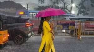
The plains of Northwest India, encompassing Punjab, Haryana, Chandigarh, Delhi, West Uttar Pradesh, and Rajasthan, are forecast to experience light to moderate rainfall. This rain will likely be accompanied by isolated thunderstorms, flashes of lightning, and gusty winds, potentially reaching speeds of 30-40 kilometers per hour. Such wind speeds can cause minor disruptions, including damage to temporary structures and challenges for outdoor activities.
Local news reports from various districts highlight the agricultural concerns. Farmers in Punjab and Haryana, whose Rabi crops are in critical stages, are particularly wary of hailstorms. The IMD specifically warns of isolated hailstorms over parts of Punjab, Haryana, West Uttar Pradesh, and Rajasthan on April 7th. Hail can devastate standing crops, leading to significant economic losses for agricultural communities. Authorities are urging farmers to take necessary precautions to protect their produce where possible.
Moving towards the mountainous regions, the outlook becomes more severe. Jammu & Kashmir, Ladakh, Himachal Pradesh, and Uttarakhand are expected to witness light to moderate rainfall or snowfall. This period of precipitation is projected to last from April 6th to April 9th, with isolated thunderstorms and lightning also a possibility. The higher reaches of these states could see significant snow accumulation, potentially affecting road connectivity and daily life.
Specific warnings for heavy rainfall or snowfall have been issued for Jammu & Kashmir, Ladakh, and Himachal Pradesh on both April 7th and 8th. Uttarakhand is also slated for isolated heavy rainfall or snowfall on April 8th. Travelers planning trips to these scenic destinations during this period are strongly advised to check local weather advisories and road conditions before embarking on their journeys. Landslides and disruptions to transportation networks are a real possibility.
In West Rajasthan, a different kind of atmospheric event is also on the cards: duststorms are anticipated on April 7th and 8th. These conditions can significantly reduce visibility, posing hazards for drivers and affecting air quality.
Preparing for the Change
The weather department’s timely alerts provide a crucial window for residents and authorities to prepare. For urban centers like Delhi, while the maximum temperature has seen fluctuations, the upcoming rain and winds could bring a temporary dip, offering a brief respite from the early summer warmth. However, waterlogging in low-lying areas and traffic snarls are common concerns during such spells. Civic bodies are expected to remain vigilant to manage these issues.
Local administrations in various states, from the district collectorates in Haryana to the disaster management cells in Himachal Pradesh, are closely monitoring the situation. Advisories are being circulated to ensure public safety. Fishermen are often cautioned against venturing into choppy waters if the disturbances extend their influence. For the general public, simple precautions can make a significant difference. Securing loose outdoor items, staying indoors during peak thunderstorm activity, and exercising caution while driving on wet or snow-covered roads are highly recommended.
Omni 360 News continues to monitor these developments, providing updates as they emerge from official sources. The dynamic nature of weather systems necessitates ongoing attention to advisories from the India Meteorological Department and state weather bureaus. Reliable and local sources remain vital for granular information pertinent to specific localities.
Key Takeaways for Northwest India Weather
- Two Western Disturbances will impact Northwest India, peaking on April 7th and 8th.
- Plains (Punjab, Haryana, Delhi, West UP, Rajasthan) expect light to moderate rain, thunderstorms, lightning, and gusty winds (30-40 kmph).
- Isolated hailstorms are likely over Punjab, Haryana, West UP, and Rajasthan on April 7th, posing a risk to agriculture.
- Himalayan regions (J&K, Ladakh, HP, Uttarakhand) forecast light to moderate rain/snowfall from April 6th-9th.
- Heavy rain/snow is very likely over J&K, Ladakh, and Himachal Pradesh on April 7th & 8th, and over Uttarakhand on April 8th.
- West Rajasthan may experience duststorms on April 7th and 8th, reducing visibility.
- Residents are advised to stay updated with IMD advisories, take precautions against gusty winds and hail, and exercise caution while traveling, especially in hilly areas.
This period of atmospheric turbulence underscores the intricate relationship between global weather patterns and regional impacts. As the two Western Disturbances make their presence felt, preparedness and vigilance will be key to navigating the upcoming days safely across Northwest India. Stay informed with Omni 360 News for the latest updates.