play
Lebanon’s Border Bleeds: Homes Vanish in Satellite Gaze
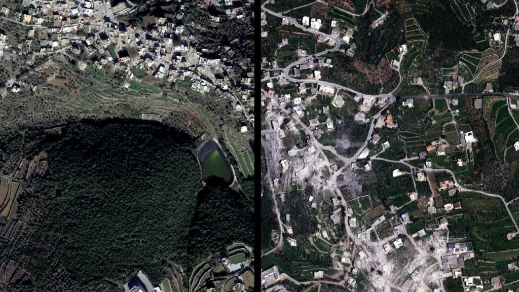
Imagine returning home to nothing but dust and twisted metal. For thousands living in south Lebanon, that nightmare is horrifyingly real. Their villages, once vibrant and full of life, have been systematically reduced to rubble. Satellite images don’t just show buildings gone; they reveal lives shattered, communities erased from the map, all seen from miles above the earth. This isn’t just about statistics; it’s about people who’ve lost everything, forced to flee what was once their sanctuary.
New, detailed analysis of satellite imagery released recently lays bare the shocking scale of destruction in towns like Kfar Kila, Houla, and Ayta al-Shaab. Experts poring over these high-resolution pictures confirm what residents already knew: their homes aren’t just damaged, they’re gone. The images, gathered by various intelligence groups and verified by organizations like Al Jazeera and UNOSAT, paint a stark, undeniable picture. We’re not talking about a few isolated structures; entire neighborhoods are leveled, critical infrastructure decimated. This isn’t an accident; it’s the grim, visible consequence of intensified cross-border shelling between Israeli forces and Hezbollah, a conflict that escalated dramatically following the events of October 7th and has continued relentlessly.
What do these images really tell us?
These aren’t just pixels on a screen. Each flattened structure represents a family’s history, a small business, a local school, a cherished place of worship. The sheer scope of the damage, glaringly visible from space, highlights a grim reality on the ground: a systematic pattern of destruction, often targeting areas suspected of harboring militants. But the line between military target and civilian dwelling blurs tragically and frequently in these conflicts. The international community often speaks of de-escalation, yet from this satellite’s vantage point, the exact opposite appears true. The silence of these ravaged towns, captured by orbiting eyes, screams louder than any explosion. It’s a stark reminder that war’s reach extends far beyond the immediate frontline, leaving lasting scars on the earth and its people, wounds that will take generations to heal.
South Lebanon towns are devastated by Israeli strikes. Satellite images confirm widespread destruction of homes and infrastructure in places like Kfar Kila. This is a grim consequence of intensified cross-border clashes with Hezbollah since October, displacing thousands and erasing communities from the map.
For those watching this conflict from afar, these images offer an unfiltered, sobering truth. They serve as a stark counter-narrative to the often-sanitized reports of military operations. This isn’t abstract strategy; it’s tangible loss, documented by impartial eyes in the sky. It begs the question: how much more will be lost before a genuine cessation of hostilities can take hold? The human cost is immeasurable, but the physical cost is now meticulously mapped, a testament to the brutal reality facing countless innocent families caught in a devastating regional struggle. The world must not look away from these silent, soaring images of suffering.