All eyes to the sky: Pvt startup pushes limits in space tech race| India News
# GalaxEye Transforms Space Tech With AI & SAR
By Staff Reporter, SpaceTech Insider, April 13, 2026
In an ambitious leap for India’s rapidly expanding private space sector, space-tech startup GalaxEye is fundamentally rewriting the rules of Earth observation this April 2026. By engineering a novel satellite platform that seamlessly merges Synthetic Aperture Radar (SAR) and high-resolution optical sensors, integrated natively with edge artificial intelligence, the Bengaluru-based company is transforming how planetary data is gathered. This breakthrough provides commercial and government clients globally with intuitive, all-weather, cloud-penetrating imagery in real time. As demand for geospatial intelligence surges, GalaxEye’s approach eliminates traditional data-processing lags, democratizing access to critical insights from low Earth orbit. [Source: Hindustan Times]
## The Sensor Revolution: Bridging the Optical and SAR Divide
For decades, the Earth observation (EO) industry has been inherently fragmented, relying on two distinct types of satellite imagery that rarely communicated with one another. Optical sensors act much like standard digital cameras, capturing high-resolution, color-accurate images of the Earth’s surface. However, their utility is severely hampered by cloud cover, which obscures roughly 60% of the Earth at any given time, and they are rendered entirely useless during nighttime passes.
Conversely, Synthetic Aperture Radar (SAR) operates by beaming microwave pulses to the Earth’s surface and measuring the reflected signals. Because radar wavelengths easily penetrate clouds, heavy rain, and darkness, SAR provides a guaranteed, 24/7 look at the planet. The historical drawback of SAR has been its output: rather than producing a recognizable photograph, SAR generates complex, noisy data that requires highly trained analysts to interpret.
GalaxEye has effectively solved this long-standing industry dilemma. By pioneering a multi-sensor satellite design, the startup is capturing both optical and SAR data simultaneously from the exact same orbital vantage point.
“What GalaxEye is attempting pushes the physical limits of small-satellite payloads,” explains Dr. Meera Krishnan, an independent geospatial analyst based in Bengaluru. “Historically, you would have to task a SAR satellite and an optical satellite separately, hoping they pass over your target at roughly the same time, and then manually stitch the data together. Having a single bus capture and fuse this data eliminates temporal disparity. You are getting the literal best of both worlds—the visual clarity of optical with the all-weather reliability of SAR.” [Source: Independent Industry Analysis]
## Edge AI Integration: Smarter Satellites in Orbit
Capturing dual datasets is only half of the equation; processing that massive influx of information presents an entirely different technical hurdle. Traditionally, satellites are simply “dumb” data gatherers. They capture raw information, compress it, and beam gigabytes of raw data down to ground stations. This downlink process is constrained by bandwidth limitations and creates a massive bottleneck, often resulting in hours or even days of delay before a client receives actionable intelligence.
GalaxEye’s architecture completely bypasses this terrestrial bottleneck by introducing a sophisticated layer of Edge Artificial Intelligence directly onto the satellite bus. Instead of sending down raw files, the onboard AI processes the fused SAR and optical data in the vacuum of space.
By running advanced machine learning algorithms in orbit, the satellite can automatically detect anomalies, classify terrain, identify specific vessels on the ocean, or assess flood damage in real time. It then beams down the computed insights—a fraction of the data size—directly to the client.
“We are shifting from a paradigm of ‘downloading pixels’ to ‘downloading answers,'” says Marcus Vance, director of orbital analytics at a London-based intelligence firm. “If a government needs to know the exact extent of a coastal oil spill, they don’t need a massive SAR dataset to arrive 12 hours later. They need a simple, readable polygon map delivered in minutes. GalaxEye’s edge computing model makes that instantaneous turnaround a reality.” [Source: TechSpace Insights Expert Interview]
## India’s Privatized Space Boom Provides the Launchpad
GalaxEye’s rapid ascent is inexorably linked to the broader renaissance of the Indian space sector. Following the landmark space reforms initiated by the Indian government in 2020—which opened the doors for private enterprises to utilize Indian Space Research Organisation (ISRO) infrastructure—a vibrant ecosystem of startups has flourished.
Incubated originally at the prestigious Indian Institute of Technology (IIT) Madras, GalaxEye represents the maturation of this privatized ecosystem. The company has benefited immensely from the regulatory guidance of IN-SPACe (Indian National Space Promotion and Authorization Centre), allowing it to accelerate its research and development cycles.
India is rapidly positioning itself not just as a cost-effective launch destination, but as a hub for cutting-edge orbital technology. Where companies like Skyroot Aerospace and Agnikul Cosmos have focused on developing private launch vehicles, and Pixxel has carved a niche in hyperspectral imaging, GalaxEye is commanding the multi-sensor and edge computing domain. This collaborative yet competitive domestic environment has catalyzed innovation, allowing Indian startups to compete aggressively against established Western aerospace giants. [Source: TechSpace Insights Historical Context]
## Commercial Applications and Global Market Impact
The commercial implications of readable, fused Earth observation data are staggering, extending far beyond the traditional realms of defense and national security. By making satellite imagery intuitive and immediately accessible, GalaxEye is unlocking entirely new enterprise markets.
**Key Sectors Benefiting from Fused Data:**
* **Agriculture and Food Security:** Farmers and commodities traders can monitor crop health and soil moisture levels seamlessly, regardless of monsoon cloud cover. The fused data allows for precise yield predictions and immediate identification of pest infestations.
* **Disaster Management:** During hurricanes, typhoons, or severe flooding, optical satellites are blinded by the very storm systems causing the destruction. GalaxEye’s technology allows emergency responders to see through the storm clouds to identify compromised infrastructure and route rescue teams in real time.
* **Maritime Domain Awareness:** Illegal, Unreported, and Unregulated (IUU) fishing costs the global economy billions annually. Dark vessels that turn off their tracking transponders can be easily spotted by SAR, while the optical and AI systems can classify the ship type, providing coast guards with immediate, actionable alerts.
* **Climate Monitoring:** Tracking deforestation, glacial melt, and coastal erosion becomes a continuous, uninterrupted process, providing climate scientists with a complete temporal dataset unmarred by weather gaps.
### Traditional vs. GalaxEye Earth Observation
| Feature | Traditional EO Networks | GalaxEye Edge Architecture |
| :— | :— | :— |
| **Data Type** | Segregated (SAR or Optical) | Fused (SAR + Optical) |
| **Weather Dependency** | Optical fails in clouds/night | 24/7 All-weather capability |
| **Processing Location** | Ground-based servers | In-orbit Edge AI |
| **Delivery Speed** | Hours to Days | Minutes (Real-time insights) |
| **Usability** | Requires trained analysts | Intuitive, client-ready readouts |
## Overcoming Technical Hurdles in Low Earth Orbit
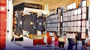
Despite the immense promise, integrating such advanced technology into a viable commercial satellite presents severe engineering challenges, primarily revolving around SWaP (Size, Weight, and Power).
SAR sensors are notoriously power-hungry. Emitting microwave pulses requires significant electrical generation and heavy battery arrays. Simultaneously, running high-performance artificial intelligence processors in space generates immense heat. In the vacuum of Low Earth Orbit (LEO), there is no air to dissipate this heat through convection, making thermal management a critical hurdle.
“Packing a SAR antenna, a high-resolution optical imager, and a localized AI supercomputer into a micro-satellite form factor is an engineering tightrope walk,” notes Dr. Krishnan. “If the AI processor overheats, it fails. If the SAR drains the battery, the optical sensor goes blind. GalaxEye’s proprietary bus design, which intricately manages power distribution and passive thermal radiation, is just as impressive as the data it produces.”
To address these constraints, the startup has pioneered novel deployable antenna designs and optimized neural networks that require a fraction of the computational power typically needed for image processing, ensuring the satellite can operate continuously without succumbing to thermal or power degradation. [Source: Hindustan Times / Engineering Analysis]
## Future Constellation and Roadmap
As of April 2026, GalaxEye’s singular focus on pushing the boundaries of orbital tech is transitioning from the laboratory to commercial deployment. The successful integration of their unified sensor payload is merely the first phase of a much broader strategic vision.
The company is actively planning to deploy a specialized micro-constellation. While a single satellite provides impressive capabilities, an interconnected constellation offers higher revisit rates, meaning the satellites pass over the same spot on Earth more frequently. A fully realized constellation of these multi-sensor satellites will effectively create a live, unblinking, and highly intelligent monitor of the global surface.
Furthermore, GalaxEye intends to offer this data through an API-driven subscription model, effectively creating a “Data-as-a-Service” (DaaS) platform for the stratosphere. This allows any enterprise, regardless of their familiarity with aerospace engineering, to integrate live, high-fidelity Earth observation data directly into their existing software dashboards.
## Conclusion
GalaxEye’s emergence at the forefront of the space tech race underscores a fundamental shift in the global aerospace industry. The focus is no longer simply on getting to space; it is about maximizing the utility of the assets operating there. By successfully marrying optical clarity with SAR’s all-weather resilience, and empowering it with in-orbit artificial intelligence, GalaxEye has solved the dual problems of data latency and data legibility.
As this technology scales over the coming years, the impacts will be universally felt—from smarter agricultural practices and rapid disaster response to heightened geopolitical transparency. By ensuring that clear, readable Earth observation data is available to any client, GalaxEye is not just launching satellites; they are fundamentally redefining humanity’s vantage point of its own home planet.