Map on the Census portal shows Arunachal town in China, error corrected| India News
# Census Map Fixes Arunachal Border Error
By Siddharth Rao, National Desk Editor, India Strategic Times, April 20, 2026.
On Sunday, Indian authorities swiftly corrected a glaring cartographic error on the official Census portal after its map interface falsely labeled a town in Arunachal Pradesh’s East Siang district as ‘Medog’, a Chinese city located across the Line of Actual Control (LAC). The discrepancy, which effectively mirrored Beijing’s contested territorial claims over the northeastern state, sparked immediate concern after a local resident flagged the glitch. The swift rectification by the government highlights the extreme sensitivities surrounding India’s territorial sovereignty and exposes the growing challenges of overseeing third-party digital mapping integrations on critical state infrastructure. [Source: Hindustan Times]
## The Discovery of the Cartographic Glitch
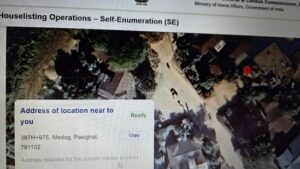
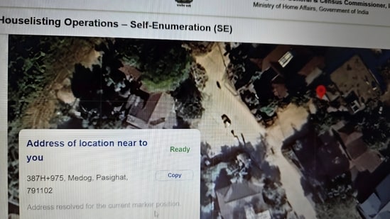
The incident came to light late last week when a resident of Arunachal Pradesh’s East Siang district logged into the official Census of India portal to verify local demographic data. While navigating the interactive map interface designed to display district and sub-district boundaries, the user noticed a severe anomaly. Instead of displaying the correct Indian nomenclature for the town, the map rendered the area under the name ‘Medog’—the official Chinese designation for a county located in the Tibet Autonomous Region, situated just north of the LAC.
**East Siang**, with its headquarters in Pasighat, is a vital administrative and culturally significant district fully administered by India. The appearance of Chinese nomenclature on an official Indian government website understandably triggered immediate alarm. Screenshots of the portal quickly circulated among local administrative circles, prompting an urgent notification to the Ministry of Home Affairs (MHA) and the Office of the Registrar General and Census Commissioner.
The error was particularly jarring because it appeared on the official Census portal, a platform that serves as the definitive digital repository for India’s demographic and geographic data. While isolated glitches in digital mapping are common on private platforms, their occurrence on a sovereign state’s premier data portal carries heavy symbolic and political weight. [Source: Hindustan Times | Additional: Public domain geographic data of Arunachal Pradesh].
## Prompt Rectification by Authorities
Upon receiving reports of the cartographic misrepresentation, the backend technical team managing the Census portal initiated immediate corrective protocols. By late Sunday evening, April 19, 2026, the erroneous map tiles were purged from the system, and the correct Survey of India (SOI) compliant boundaries and nomenclatures were restored.
Sources within the IT ministry indicated that the portal was temporarily put into maintenance mode to prevent further dissemination of the incorrect map. The technical audit revealed that the issue stemmed from a dynamic map rendering API (Application Programming Interface) that had inadvertently pulled localized geographic names from an international, open-source database rather than the mandated indigenous geographic repositories.
“The integrity of India’s cartographic representation is non-negotiable. As soon as the anomaly in the map rendering layer was identified, our technical teams bypassed the faulty third-party API and restored the officially mandated geo-spatial data,” stated a senior technical officer familiar with the government’s digital infrastructure, speaking on the condition of anonymity.
## Geopolitical Sensitivities and Border Disputes
To understand the gravity of this digital error, it is essential to contextualize it within the ongoing geopolitical friction between New Delhi and Beijing. China routinely claims the entirety of Arunachal Pradesh, referring to the region as “Zangnan” or South Tibet. Over the past decade, Beijing has escalated a strategy of “cartographic aggression,” repeatedly releasing standardized lists of Chinese names for Indian towns, mountains, and rivers in Arunachal Pradesh.
These renaming exercises—most notably the extensive lists published by China’s Ministry of Civil Affairs in 2017, 2021, 2023, and 2024—are widely viewed by international relations experts as attempts to build a fabricated historical and administrative narrative to legitimize illegal territorial claims.
India has consistently and resolutely rejected these actions. The Ministry of External Affairs (MEA) maintains a staunch position, frequently reiterating that “Arunachal Pradesh is, has been, and will always remain an integral and inalienable part of India.” The MEA has repeatedly stated that assigning invented names does not alter the sovereign reality on the ground. Therefore, an Indian state portal momentarily reflecting this foreign propaganda—even due to a software glitch—represents a highly sensitive security oversight. [Source: Hindustan Times | Additional: Geopolitical analysis of Sino-Indian border disputes].
## The Technological Vulnerability: Third-Party APIs
The root cause of this incident lies in the complex architecture of modern web development. Government portals frequently rely on Geographic Information Systems (GIS) to visually present complex demographic data. To build these interfaces efficiently, developers sometimes integrate global, open-source map layers (such as OpenStreetMap variations) or third-party commercial mapping APIs.
These international platforms dynamically generate map “tiles” based on global datasets. In regions with disputed borders, international mapping services often use algorithms that display different boundaries depending on the user’s IP address, or they default to neutral, internationally recognized dispute lines. However, if an API is improperly configured, or if an open-source database is subjected to “cartographic vandalism” (where users maliciously edit border names), those errors can bleed into the platforms utilizing the service.
In the case of the Census portal, it appears the spatial data layer momentarily fetched a nomenclature packet heavily influenced by Chinese geographic submissions to international open-source registries, resulting in the East Siang town being labeled as ‘Medog’.
To combat this, the Indian government established the National Geospatial Policy, which mandates that all official government digital infrastructure must utilize map services compliant with the Survey of India, ensuring that the country’s sovereign boundaries and official names are accurately represented without reliance on vulnerable external APIs.
## Expert Perspectives on ‘Cartographic Aggression’
Digital mapping experts and geopolitical analysts emphasize that digital infrastructure is the modern frontier of border defense.
“Maps are no longer merely navigational tools; they are the frontline of cognitive warfare and geopolitical posturing,” notes Dr. Amitabha Desai, a strategic affairs analyst specializing in Sino-Indian relations. “When China renames Indian territories, their goal is to flood global digital databases with their nomenclature. If an Indian government website inadvertently uses a compromised database, it hands Beijing an unintended propaganda victory. This incident underscores the urgent need for a fully sovereign, self-reliant digital mapping ecosystem for all state machinery.”
Dr. Desai further elaborated that digital audits of government websites must go beyond standard cybersecurity checks (like preventing hacks or data breaches) to include rigorous “spatial data audits” to ensure no cartographic subversion occurs via automated software updates.
## Historical Context of Digital Map Controversies
This is not the first time digital platforms have faced scrutiny over the misrepresentation of Indian territories. The intersection of global technology and sovereign borders has historically been a friction point.
**Table: Recent Instances of Cartographic Discrepancies Involving India**
| Year | Entity/Platform | Nature of Discrepancy | Resolution |
| :— | :— | :— | :— |
| **2020** | Global Social Media Giant | Displayed Leh (Ladakh) as part of China in live broadcasts. | Corrected following severe backlash and government notices. |
| **2021** | International Health Body (WHO) | Color-coded Jammu & Kashmir differently from the rest of India on a COVID-19 dashboard. | Modified with a disclaimer citing UN guidelines, causing diplomatic friction. |
| **2022** | Multinational Tech Company | Showed a distorted map of India excluding parts of Kashmir on its corporate website. | Apologized and updated the map to reflect official SOI boundaries. |
| **2026** | Census of India Portal | Briefly labeled an East Siang town as ‘Medog’ due to an API error. | Corrected immediately within hours by the Ministry of Home Affairs. |
*Data compiled from historical public records and tech policy reports.*
These incidents have led to the tightening of India’s Geospatial Information Regulation frameworks. The regulations make it legally binding for entities operating within India to depict the nation’s borders in strict accordance with official guidelines, with heavy penalties for platforms that disseminate incorrect maps.
## Conclusion: Safeguarding Digital Borders
The quick resolution of the Census portal map error averts what could have been a major diplomatic and domestic embarrassment for the administration. However, it serves as a critical wake-up call regarding the vulnerabilities of digital supply chains in software development.
**Key Takeaways:**
* **Vigilance is Crucial:** The fact that a local citizen spotted the error demonstrates the importance of public vigilance in the digital age.
* **Sovereign Tech Infrastructure:** Reliance on international open-source map APIs carries inherent risks for government platforms. Transitioning fully to indigenous platforms like Bhuvan (developed by ISRO) and Survey of India APIs is a national security imperative.
* **Cognitive Warfare:** As nations utilize digital data to assert territorial claims, “cartographic hygiene” becomes as critical as physical border security.
Looking ahead, the Ministry of Electronics and Information Technology (MeitY) is expected to issue a renewed directive mandating comprehensive spatial audits for all central and state government portals. As technology continues to blur the lines between physical territory and digital representation, safeguarding the nation’s cartographic identity will require continuous, specialized technological oversight.
For the residents of East Siang, the quick correction is a reassurance that their identity remains firmly protected. Yet, the broader implication remains clear: the defense of a nation’s borders today requires vigilant soldiers not just in the high Himalayas, but also in the server rooms managing its digital footprint.