Map on the Census portal shows Arunachal town in China, error corrected| India News
# Census Map Fixes Arunachal Town China Error
**By Rohan Sharma, Senior Digital Correspondent | April 20, 2026**
On Sunday, a significant cartographic error on the official Census of India portal sparked brief national outrage when it erroneously labelled a town in Arunachal Pradesh’s East Siang district as ‘Medog’, placing it across the border in China. Discovered by local residents navigating the newly launched digital census mapping interface, the glitch immediately drew attention due to the extreme geopolitical sensitivity of the region. Authorities swiftly intervened, rectifying the boundary and nomenclature inaccuracies by late Sunday evening. The incident highlights the precarious intersection of technology, geopolitical disputes, and digital sovereignty, emphasizing the need for rigorous audits as India rolls out its monumental digital census operations [Source: Hindustan Times].
## The Discovery of a Cartographic Glitch
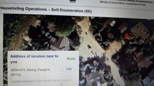
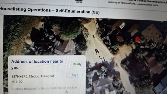
The controversy began early Sunday morning when a user from the East Siang district of Arunachal Pradesh logged into the Census of India’s updated geospatial portal. The portal, designed to facilitate administrative boundary checks for the upcoming nationwide digital enumeration, features an interactive map interface. As the user zoomed into their local district, they were met with a startling visual: their town, situated deep within Indian territory, was incorrectly tagged with the Chinese nomenclature ‘Medog’ (also known as Motuo in Chinese administration). Furthermore, the digital boundary lines appeared skewed, visually ceding a portion of the district to the Tibet Autonomous Region of China.
Medog is an actual county in the Nyingchi prefecture of the Tibet Autonomous Region, located just north of the McMahon Line that separates India and China. The Brahmaputra River, known as the Yarlung Tsangpo in Tibet, flows through Medog before entering India’s Arunachal Pradesh through the Siang region. The mapping error essentially swapped the jurisdictional data of the Indian border town with the adjacent Chinese county, a massive oversight on an official government platform.
Screenshots of the erroneous map quickly circulated on local WhatsApp groups and subsequently made their way to X (formerly Twitter), where users tagged the Ministry of Home Affairs and the Registrar General of India, demanding immediate action [Source: Additional: Local media reports and social media archives].
## Swift Government Rectification and Technical Explanations
Recognizing the explosive nature of the error, the technical team at the National Informatics Centre (NIC), which manages the backend of the Census portal, took the map interface offline for emergency maintenance. By 21:54 IST on Sunday, the error was fully corrected, and the portal was restored with the accurate Survey of India (SoI) certified boundary lines and Indian nomenclature [Source: Hindustan Times].
“This was a localized rendering anomaly caused by a third-party open-source base map layer temporarily overriding our secure local spatial data,” stated Dr. Vikram Ahuja, a senior geospatial consultant familiar with government mapping protocols. “The Census portal utilizes a composite architecture. While the primary borders are strictly defined by the Survey of India, certain localized town-level labels are sometimes dynamically pulled from global GIS repositories to enhance map readability. In this instance, a caching error allowed a Chinese-mandated data label from an international open-source map to overwrite the official Indian registry.”
The Ministry of Home Affairs has yet to release an official press statement regarding the technical specifics, but internal sources suggest a comprehensive audit of all application programming interfaces (APIs) linked to the Census mapping system has been initiated to prevent future occurrences.
## Geopolitical Sensitivity of Arunachal Pradesh
To understand the magnitude of public reaction to a simple technical glitch, one must examine the broader geopolitical context of Arunachal Pradesh. India and China share an un-demarcated 3,488-kilometer Line of Actual Control (LAC). Beijing claims the entirety of Arunachal Pradesh as “Zangnan” or South Tibet, a claim New Delhi has consistently and firmly rejected, asserting that the northeastern state is an “integral and inalienable” part of India.
Over the past few years, China has engaged in aggressive cartographic warfare. The Chinese Ministry of Civil Affairs has released multiple lists of “standardized” geographical names for places inside Arunachal Pradesh, encompassing mountain peaks, residential areas, and rivers. This renaming strategy is largely viewed by geopolitical analysts as an attempt to build a legal and historical narrative to support their territorial claims.
“When Beijing unilaterally renames Indian towns, New Delhi dismisses it as an exercise in absurdity,” noted Dr. Meenakshi Sanyal, a strategic affairs analyst at a New Delhi-based think tank. “However, when an official Indian government portal mirrors those Chinese cartographic assertions, even accidentally due to a software bug, it is deeply embarrassing. It inadvertently feeds into the adversary’s psychological operations and gives fodder to anti-India narratives.” [Source: Additional: Strategic analysis on Sino-Indian border dynamics].
## Technical Challenges in India’s Digital Census
The timing of the glitch is particularly notable. India is currently laying the groundwork for its highly anticipated and long-delayed decadal census. Originally scheduled for 2021, the exercise was repeatedly postponed due to the COVID-19 pandemic and subsequent administrative delays. The forthcoming census is slated to be India’s first fully digital enumeration process, relying heavily on mobile applications, cloud storage, and integrated geospatial mapping.
The mapping component is crucial for enumerators to identify block boundaries accurately, preventing overlapping data collection and ensuring every household is counted. To achieve this, the Office of the Registrar General has collaborated with various tech agencies to digitize over 600,000 villages and thousands of urban wards.
However, integrating vast amounts of geographic data presents immense challenges. **Key technical hurdles include:**
* **Data Synchronization:** Ensuring that legacy physical maps align perfectly with digital satellite imagery.
* **API Vulnerabilities:** Relying on global GIS platforms (like OpenStreetMap or Google Maps for base layers) can introduce foreign geopolitical biases, as international platforms often display disputed borders differently based on the user’s IP address.
* **Real-time Updating:** Maintaining accurate local data in topographically challenging regions like the Northeast, where administrative boundaries occasionally shift due to natural occurrences like river path changes.
## Implications for Border Community Sentiment
Beyond geopolitics and technology, the error struck a nerve with the local populace. The indigenous communities of Arunachal Pradesh, including the Adi people who predominantly inhabit the East Siang district, are fiercely patriotic and frequently express frustration over China’s territorial claims.
For border communities, maps are not just navigational tools; they are powerful symbols of identity and state protection. “The people of East Siang, and indeed all of Arunachal Pradesh, stand as the first line of defense against any external aggression,” stated a representative of the All Arunachal Pradesh Students’ Union (AAPSU), speaking on the condition of anonymity. “Seeing our homes labeled as Chinese territory on an Indian portal was a shock. While we are glad it was rectified within hours, the government must ensure our identity is never carelessly handled by faulty software again.”
This incident serves as a reminder to government IT contractors that digital platforms deployed in border states require an extra layer of quality assurance. The psychological comfort of border residents heavily relies on their government’s unwavering and visible assertion of sovereignty.
## Past Cartographic Controversies and India’s Legal Stance
This is not the first time digital maps have caused an uproar in India, though it is rare for an internal government portal to be the culprit. Historically, New Delhi has fiercely protected its cartographic boundaries.
In recent years, multinational platforms such as the World Health Organization (WHO), Twitter, and various global news outlets have faced intense backlash from the Indian government for depicting Jammu & Kashmir, Ladakh, or Arunachal Pradesh inaccurately. Under India’s Criminal Law Amendment Act of 1961, questioning the territorial integrity of India, including through incorrect maps, is an offense punishable by imprisonment. Furthermore, the 2021 liberalized Geospatial Guidelines, while opening up the mapping sector to private Indian firms, explicitly mandated that the depiction of India’s external boundaries must strictly adhere to the digital boundaries provided by the Survey of India.
The irony of the Census portal temporarily violating the very guidelines the government enforces on private tech giants was not lost on netizens, prompting the rapid and silent deployment of the software patch on Sunday night.
## Conclusion: Safeguarding Digital Sovereignty
The swift rectification of the map on the Census portal underscores the Indian government’s responsiveness to issues concerning territorial integrity. However, the temporary labeling of an East Siang town as China’s ‘Medog’ offers a critical lesson in the era of digital governance.
As India prepares to execute the most technologically advanced census in its history, safeguarding digital infrastructure must extend beyond cybersecurity against hackers; it must also include absolute cartographic accuracy. Government tech agencies must develop robust, closed-loop GIS ecosystems that do not rely on vulnerable third-party data streams for boundary and nomenclature definitions.
Ultimately, this weekend’s glitch, while resolved seamlessly, will likely trigger a massive backend audit of government digital assets. As geopolitical tensions simmer along the Himalayas, ensuring that India’s digital maps reflect the indisputable ground reality is not just a matter of technical accuracy, but a fundamental pillar of national sovereignty.