All eyes to the sky: Pvt startup pushes limits in space tech race| India News
# GalaxEye Pioneers Dual-Sensor Space Tech
On April 13, 2026, Indian space-technology startup GalaxEye announced a massive leap forward in the global Earth observation market, revealing plans to deploy satellites that simultaneously capture Synthetic Aperture Radar (SAR) and optical data. Operating out of Bengaluru, the company is fusing these traditionally separate data streams into a single orbital platform. By layering advanced artificial intelligence directly onto the satellite to process this data in space, GalaxEye aims to deliver universally accessible, all-weather, high-resolution satellite imagery to commercial and government clients instantly. This unprecedented engineering approach is set to drastically reduce data delivery latency and fundamentally alter how global industries monitor the planet. [Source: Hindustan Times | Additional: General Space Industry Knowledge].
## The Blind Spots in Traditional Earth Observation
For decades, the Earth Observation (EO) industry has been divided into two distinct technological camps: optical imagery and radar. Optical satellites operate much like digital cameras, capturing high-resolution, color-accurate images of the Earth’s surface. However, they possess a critical flaw: they are entirely dependent on sunlight and clear weather. With **approximately 60% of the Earth covered in clouds at any given moment**, optical satellites frequently beam down useless images of white cloud tops.
To bypass this weather limitation, the industry relies on **Synthetic Aperture Radar (SAR)**. SAR active sensors shoot microwave pulses toward the Earth and measure the backscatter. Because microwaves easily penetrate cloud cover, rain, and darkness, SAR provides true 24/7 observation capabilities. The downside is that SAR data is notoriously difficult to interpret. Instead of a clear photograph, SAR produces complex, textured grayscale datasets that require highly trained analysts and specialized software to decode.
Historically, a client needing both clear visual context and all-weather reliability had to purchase data from two different satellite constellations, hoping their orbital passes aligned closely in time—a rare and expensive occurrence. [Source: Hindustan Times | Additional: Earth Observation Market Analysis].
## Merging Data Streams: The Drishti Sensor Paradigm
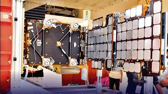
GalaxEye Space, founded by a team of alumni from the Indian Institute of Technology (IIT) Madras, recognized that the segregation of optical and radar data was a bottleneck for industries requiring real-time situational awareness. To solve this, the startup developed the **”Drishti” multi-sensor payload**.
The Drishti sensor is designed to house both SAR and optical instruments within the same compact satellite chassis. As the satellite orbits the Earth, both sensors simultaneously capture data of the exact same geographical area.
“What GalaxEye is attempting represents a holy grail in orbital remote sensing,” notes Dr. Arindam Bose, a senior satellite systems architecture analyst at GeoSpace Insights. “Synchronizing radar backscatter with visual spectrum data from the exact same vantage point and timestamp eliminates the complex geometrical corrections usually required to merge datasets from disparate satellites. It provides the ultimate ground truth.”
By co-registering the SAR and optical data natively, GalaxEye’s platform creates a composite image that retains the cloud-penetrating structural data of radar, colorized and contextualized by whatever optical data can be gathered through gaps in the weather. [Source: Hindustan Times | Additional: Institutional Space Research Archives].
## Edge AI: Transforming Orbiting Hardware into Smart Analysts
Capturing dual-stream data is only half the battle; transmitting it back to Earth presents an immense logistical hurdle. SAR data files are notoriously massive. Beaming down raw optical and SAR data simultaneously would quickly overwhelm the bandwidth limits of small satellite communication arrays, creating a massive data bottleneck at ground stations.
To circumvent this, GalaxEye is introducing **Edge Artificial Intelligence** directly into the satellite’s onboard computers. Rather than acting as a simple “dump pipe” that sends raw data to servers on Earth, the satellite functions as an orbital data center.
The onboard AI algorithms are trained to instantly ingest the raw SAR and optical data, run complex sensor-fusion models, and generate a synthesized, easily readable image map. The AI can automatically identify specific parameters—such as flooded areas, ship wakes, or infrastructure damage—and compress this heavily processed intelligence into a lightweight file.
By the time the satellite passes over a ground station, it beams down the finished, readable product rather than the raw code. This reduces data transmission times from hours to mere minutes, ensuring that clients receive actionable intelligence when it matters most.
## Democratizing Space Data Across Industries
The commercial implications of making fused SAR-optical data “readable to any client” are vast. The global Earth observation market, valued at roughly **$8.5 billion in 2023, is projected to surpass $14.6 billion by 2030**. GalaxEye’s approach threatens to disrupt traditional data providers by expanding the customer base beyond specialized geospatial engineers.
Key sectors positioned to benefit include:
* **Agriculture:** Farmers and commodities traders can monitor crop health and soil moisture through monsoon clouds. The AI can automatically highlight areas suffering from blight or drought without requiring the farmer to understand radar phase shifts.
* **Maritime Security:** Illegal, Unreported, and Unregulated (IUU) fishing often occurs at night or under heavy cloud cover, with vessels turning off their transponders. GalaxEye’s SAR can detect the physical ships, while the optical sensor and AI attempt to identify vessel types, beaming coordinates directly to coast guards.
* **Disaster Management:** During hurricanes or severe floods, heavy cloud cover persists for days, blinding traditional optical satellites. First responders can use GalaxEye’s AI-processed maps to see exactly which roads are washed out and which buildings are submerged, allowing for immediate triage.
* **Defense and Intelligence:** Continuous, weather-agnostic border monitoring becomes significantly cheaper and more accessible for defense agencies.
| Feature | Traditional Observation Systems | GalaxEye ‘Drishti’ Architecture |
| :— | :— | :— |
| **Weather Dependency** | High (Optical), Low (SAR) | None (SAR + Optical Fusion) |
| **Data Format** | Separated, complex raw data | Synthesized, visually intuitive |
| **Processing Location** | Ground stations (Earth) | Edge computing (In-orbit) |
| **Delivery Latency** | 12 to 48 hours | Minutes to hours |
## India’s Evolving Privatized Space Ecosystem
GalaxEye’s rapid rise is emblematic of a broader renaissance within the Indian space sector. Following the landmark privatization reforms initiated by the Indian government and the establishment of IN-SPACe (Indian National Space Promotion and Authorization Centre), the country has transitioned from relying solely on the state-run Indian Space Research Organisation (ISRO) to fostering a vibrant private ecosystem.
By early 2026, Indian startups have begun capturing a notable share of the global commercial space market. Companies like Skyroot Aerospace and Agnikul Cosmos have secured launch capabilities, while Pixxel has pioneered hyperspectral imaging. GalaxEye fits perfectly into this new matrix, leveraging India’s deep pool of engineering talent to produce high-end orbital hardware at a fraction of the cost typical in Western markets.
“The Indian space startup ecosystem has moved past the imitation phase and is now firmly in the innovation phase,” states Meera Rao, a venture capital director focusing on deep-tech investments in South Asia. “GalaxEye isn’t just building a cheaper version of a Western satellite; they are pioneering a completely new data architecture that the legacy aerospace giants are currently scrambling to replicate.” [Source: Hindustan Times | Additional: Economic Forecasts on Indian Space Sector].
## Navigating Engineering Limitations
Despite the immense promise, integrating multi-sensor payloads and high-performance computing into a small satellite form factor presents severe engineering hurdles—most notably concerning SWaP (Size, Weight, and Power).
Active radar systems require massive bursts of electrical power to generate microwave pulses, necessitating large solar arrays and high-capacity batteries. Furthermore, running intensive AI neural networks on space-grade edge processors generates significant heat. In the vacuum of space, where there is no air to carry heat away via convection, thermal management becomes a critical point of failure.
GalaxEye’s engineers have spent the last few years developing proprietary heat dissipation panels and optimizing their AI algorithms to run on highly constrained power budgets. Their ability to successfully operationalize these solutions in the harsh radiation environment of Low Earth Orbit (LEO) will be the ultimate test of their technology as they push toward deploying a full commercial constellation.
## Conclusion: A Clearer View of Tomorrow
As the space tech race accelerates into the latter half of the decade, the demand for immediate, actionable planetary data is outstripping the capabilities of legacy satellite constellations. GalaxEye’s bold attempt to merge optical clarity with radar reliability—and distill it through the lens of artificial intelligence—represents a pivotal shift in how humanity observes its own planet.
If successful, their upcoming satellite deployments will democratize access to high-tier geospatial intelligence. By removing the barriers of cloud cover, complex data processing, and high latency, GalaxEye is not just launching hardware into orbit; they are launching a fundamentally more transparent era of global Earth observation.
**By Senior Space Correspondent**
**TechNova Aviation & Space** | **April 13, 2026**