Rain, storms to bring Delhi respite from heatwave soon. Here's what IMD said| India News
# Delhi Heatwave Ends: Rain & Storms Arrive
By Staff Reporter, The Metro Chronicle, April 27, 2026
After weeks of sweltering under an intense, unforgiving sun, residents of the National Capital Region (NCR) are finally bracing for much-needed respite. The India Meteorological Department (IMD) announced on Monday that a significant shift in weather patterns will bring rain and thunderstorms to New Delhi starting Tuesday, April 28. Driven by a fresh Western Disturbance interacting with local moisture, these changing atmospheric conditions are expected to drastically pull down daytime temperatures, officially ending the brutal late-April heatwave that has severely disrupted daily life across the capital. [Source: Hindustan Times]
## The IMD Forecast: When and Where Rain Will Fall
According to the latest meteorological bulletins, the weather in Delhi will undergo a dramatic transformation within the next 24 hours. The IMD has issued a ‘yellow alert’ for Tuesday and Wednesday, advising citizens to prepare for light to moderate rainfall accompanied by gusty winds reaching speeds of 30 to 40 kilometers per hour.
“Changing conditions will start bringing relief from Tuesday. With the return of rain, the temperature is likely to fall significantly across all NCR observatories,” noted a senior official from the Regional Meteorological Centre in New Delhi. [Source: Hindustan Times]
The transition will begin with overcast skies on Monday evening, building up to isolated thundershowers by early Tuesday morning. Areas such as Safdarjung, Palam, Ayanagar, and Ridge are expected to experience spells of rainfall, which will wash away the accumulated particulate matter and immediately lower the ambient temperature. By Wednesday, maximum daytime temperatures, which had been hovering dangerously close to 42°C (107.6°F), are predicted to plummet to a much more comfortable 34°C to 36°C.
**Temperature Trajectory for Delhi NCR (April 2026)**
| Date | Weather Status | Estimated Maximum Temp (°C) |
| :— | :— | :— |
| Sunday, April 26 | Severe Heatwave | 42.8°C |
| Monday, April 27 | Partly Cloudy, Hot | 40.5°C |
| Tuesday, April 28 | Thunderstorms & Rain | 36.0°C |
| Wednesday, April 29 | Overcast, Light Showers | 34.5°C |
| Thursday, April 30 | Mostly Clear, Breezy | 35.8°C |
## Breaking Down the Searing April Heat
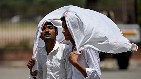
To appreciate the upcoming relief, one must look at the grueling weather Delhiites have endured over the past two weeks. April 2026 has gone on record as one of the hottest in the last decade, with consecutive heatwave days pushing the city to its limits. Areas like Najafgarh, Mungeshpur, and Narela—which typically record higher temperatures than the city’s base observatory at Safdarjung due to localized urban heat island effects—reported blistering maximums exceeding 43°C over the weekend.
The IMD defines a heatwave in the plains when the maximum temperature reaches at least 40°C and is 4.5 to 6.4 degrees above the normal average for that time of year. For multiple days in a row, Delhi met and exceeded these criteria. Streets were largely deserted during the afternoon hours, schools adjusted their timings to protect young students, and gig workers faced perilous conditions while navigating the scorching asphalt.
## Meteorological Factors Behind the Transition
The sudden shift from a baking heatwave to thunderstorms is a classic characteristic of North India’s pre-monsoon weather dynamics. The current spell of relief is primarily being driven by an active Western Disturbance. [Source: Meteorological Knowledge Base]
Western Disturbances are extra-tropical storms originating in the Mediterranean region that bring sudden winter and pre-monsoon rain to the northwestern parts of the Indian subcontinent.
Dr. Ananya Sharma, an independent climatologist and researcher based in New Delhi, explains the phenomenon: “For the past three weeks, an anti-cyclonic circulation over Rajasthan and Gujarat suppressed cloud formation and trapped hot air over the NCR. What we are seeing now is a strong Western Disturbance approaching from the Himalayas. As this cool, upper-air system interacts with warm, moisture-laden southwesterly winds coming from the Arabian Sea, it creates immense atmospheric instability. The result is the formation of cumulonimbus clouds, leading to thunderstorms, squalls, and sudden downpours.”
This interaction not only brings precipitation but also alters the wind direction. The dry, searing north-westerly winds (locally known as the *Loo*) will temporarily be replaced by cooler, moist easterly winds.
## Impact on Delhi’s Power Grid and Infrastructure
The relentless heatwave did not just test human endurance; it pushed Delhi’s utility infrastructure to the absolute brink. Power demand in the national capital surged to unprecedented levels for the month of April. Last Friday, the peak power demand breached the 7,600 Megawatt (MW) mark, fueled largely by the non-stop running of air conditioners, desert coolers, and industrial refrigeration units.
Power distribution companies (discoms) have been operating at maximum capacity, with sporadic local outages reported in densely populated neighborhoods due to overheated transformers. The anticipated rain and subsequent drop in temperature will provide a massive relief to this strained power grid. With temperatures falling by nearly 6 to 8 degrees by Wednesday, power demand is expected to plunge by at least 15-20%, allowing utility companies to perform necessary maintenance on stressed electrical nodes.
Water supply, another critical issue during the Delhi summer, will also see a brief stabilization. While a few days of rain will not replenish the drying Yamuna River or the depleting groundwater tables entirely, the reduction in evaporation rates and a temporary dip in water consumption for cooling and domestic use will give the Delhi Jal Board a brief operational buffer.
## Health Advisories and Public Safety
While the heatwave brought advisories focused on hydration and heatstroke prevention, the incoming storms bring a different set of public health and safety protocols. The sudden drop in temperature, combined with high humidity, creates an environment where viral infections, common colds, and influenza can easily spread.
Medical professionals are urging citizens to be cautious during the transition. “The human body takes time to acclimatize to sudden temperature variations,” advises Dr. Rajesh Mehta, a senior physician at a leading private hospital in Delhi. “Going from a 42-degree dry heat to a 34-degree wet and windy environment can trigger respiratory issues, particularly in children and the elderly. Furthermore, the first rains after a dry spell often lead to a spike in allergic rhinitis and asthma due to the sudden churning of dust and pollen.”
Additionally, the Delhi Traffic Police have issued warnings regarding commuting. Pre-monsoon showers in Delhi are notorious for causing brief but severe waterlogging, tree falls, and traffic snarls. Motorists are advised to drive slowly, maintain safe distances, and avoid parking under large, old trees during squalls.
## Climate Context: The New Normal for Northern India
While the impending rain is a welcome anomaly in a month characterized by extreme heat, climate scientists warn that the underlying trend remains alarming. The frequency, duration, and intensity of April heatwaves in Northwest India have steadily increased over the last two decades.
The Urban Heat Island (UHI) effect is a significant multiplier in Delhi. Heavy concretization, dwindling green cover, the loss of natural water bodies, and heat emissions from millions of vehicles and air conditioning units trap heat close to the surface. During the day, the asphalt and concrete absorb solar radiation, and at night, they release it slowly, preventing the city from cooling down adequately.
Environmentalists point out that while Western Disturbances provide episodic relief, they are not a long-term solution to the structural and climate-driven heating of the capital. According to recent climate assessments, if global greenhouse gas emissions continue at their current trajectory, cities like Delhi could face uninhabitable summer temperatures for extended periods by the mid-century. [Source: Intergovernmental Panel on Climate Change (IPCC) Regional Data]
## Looking Ahead: May Weather Outlook
The burning question on the minds of Delhi residents is how long this relief will last. The IMD’s extended forecast suggests that the cool spell will maintain lower temperatures until the upcoming weekend. By Sunday, May 3, the effect of the Western Disturbance will begin to wane, and clear skies will return.
As May begins—traditionally the hottest month of the year for Northern India—temperatures are expected to climb back up steadily. However, the residual moisture in the soil and atmosphere from this week’s rains may delay the onset of the next severe heatwave by at least a week to ten days. Citizens should expect a gradual rise in mercury, combined with increasing humidity, leading to sticky, uncomfortable conditions before the dry *Loo* winds establish dominance again in mid-May.
## Conclusion: Key Takeaways
The IMD’s latest forecast brings a collective sigh of relief to the National Capital Region. [Source: Hindustan Times] Key takeaways for the week include:
* **Significant Cooling:** Maximum temperatures will drop from the mid-40s to the mid-30s starting Tuesday, April 28, 2026.
* **Rain and Storms:** A Western Disturbance will bring gusty winds (30-40 kmph) and light to moderate rainfall across Delhi NCR.
* **Infrastructure Relief:** The drop in temperature will sharply reduce the peak power demand, easing the strain on local power grids.
* **Safety First:** Residents should transition from heatstroke precautions to being vigilant about sudden weather changes, potential waterlogging, and viral infections.
While Delhiites can look forward to enjoying a rare cool and breezy late April, it serves as a brief pause in what is shaping up to be a long, grueling summer. Preparing for the long-term impacts of extreme heat remains a priority for both the administration and the public as the calendar turns to May.