Map on the Census portal shows Arunachal town in China, error corrected| India News
# India Fixes Arunachal Map Error on Census Portal
By Siddharth Rao, National Policy Desk, April 20, 2026
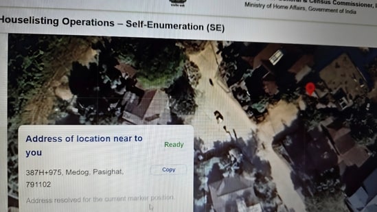
The Indian government swiftly rectified a significant cartographic blunder on its official Census portal late Sunday, April 19, 2026, after a map interface falsely labeled a sovereign Indian town in Arunachal Pradesh as Chinese territory. The digital map erroneously displayed a settlement in the East Siang district as ‘Medog’—a city located across the border in China’s Tibet Autonomous Region. The error, which inadvertently mirrored Beijing’s contested territorial claims on an official Indian platform, was corrected immediately following public and administrative detection. [Source: Hindustan Times]. This incident underscores the critical, often volatile intersection of digital infrastructure, global mapping APIs, and geopolitical sovereignty in sensitive border regions.
## Anatomy of the Cartographic Glitch
The discrepancy was first noticed by local users and administrative officials navigating the web-based GIS (Geographic Information System) modules of the upcoming national census. When zooming into the northeastern state of Arunachal Pradesh, specifically the **East Siang district**, the map interface replaced the names of local Indian settlements with Chinese nomenclature. The most glaring error was the projection of **’Medog’**, a Tibetan county situated north of the Line of Actual Control (LAC), directly onto sovereign Indian territory.
Geographically, the region is highly significant. The Yarlung Tsangpo river flows from Tibet through Medog before entering Arunachal Pradesh, where it is known as the Siang river, eventually becoming the Brahmaputra in Assam. Because of this geographic continuity, accurate demarcation of the McMahon Line—the boundary between Tibet and India’s northeast—is vital. The mislabeling essentially erased the international boundary on the digital platform, effectively annexing East Siang into Chinese territory in the digital realm.
Upon notification, the portal’s IT administrators pulled the specific map layers offline. Within hours, the interface was patched, and the boundaries were restored to align strictly with the official mandates of the **Survey of India (SoI)**, the national mapping agency.
## The Technological Pitfalls of Map Integrations
While the error on a government website is politically sensitive, technology and cybersecurity experts point out that such glitches are frequently the result of third-party API (Application Programming Interface) integrations rather than malicious internal tampering. Many government and corporate portals utilize global mapping services—such as OpenStreetMap, Mapbox, or localized forks of global GIS data—to provide interactive web features.
Global mapping platforms frequently face the “disputed borders” dilemma. To comply with local laws, global tech companies often serve different versions of the same map depending on the user’s IP address. However, when software updates are rolled out or when open-source map tiles are integrated without strict local compliance filters, international boundary representations can inadvertently bleed into local systems.
“What we witnessed on the Census portal was likely a failure in the geo-fencing and API localization protocols,” notes Dr. Rajesh Venkat, a GIS architect specializing in public sector digital infrastructure. “When pulling dynamic map tiles from global servers, if the specific filters mandating Survey of India boundaries temporarily fail or are overwritten by a broad software patch, the map defaults to international datasets. These datasets often reflect the territorial disputes recognized by the United Nations, or worse, contested claims heavily pushed by foreign state actors.” [Source: Independent Expert Analysis].
## Geopolitical Context: The Shadow of “Zangnan”
The swift reaction from New Delhi is rooted in a long history of cartographic friction with Beijing. China claims the entirety of Arunachal Pradesh, referring to it as **”Zangnan”** or South Tibet. Over the past several years, Beijing has intensified its “cartographic aggression” by releasing successive batches of standardized geographical names for places inside Arunachal Pradesh.
In 2023, China’s Ministry of Civil Affairs released a “standard map” that incorporated Arunachal Pradesh and the Aksai Chin region within its borders. Subsequent releases in 2024 and 2025 attempted to rename dozens of mountains, rivers, and residential areas within the Indian state using Mandarin and Tibetan characters.
India’s Ministry of External Affairs (MEA) has consistently and categorically rejected these claims. External Affairs Minister S. Jaishankar has repeatedly stated that “invented names will not alter reality,” reaffirming that Arunachal Pradesh is, has been, and will always remain an integral and inalienable part of India. Against this deeply polarized backdrop, an official Indian government portal displaying Chinese nomenclature is an optic that New Delhi cannot afford.
### Timeline of Recent Cartographic Frictions
| Year | Event | Implication |
| :— | :— | :— |
| **2023** | China releases “Standard Map” including Arunachal Pradesh. | Prompted strong diplomatic protests from India; map rejected by multiple ASEAN nations. |
| **2024** | Beijing issues a fourth list renaming 30 places in Arunachal. | India dismisses the move as a “senseless attempt” to alter sovereign realities. |
| **2025** | India accelerates the Vibrant Villages Programme in East Siang. | Strengthens physical and administrative presence along the LAC to counter Chinese claims. |
| **2026** | API glitch temporarily displays ‘Medog’ on India’s Census portal. | Highlights vulnerabilities in digital cartography; immediately corrected by Indian IT administrators. |
## Expert Perspectives on Digital Sovereignty
The incident brings the concept of **digital sovereignty** to the forefront of national security discussions. In the 21st century, the lines drawn on digital maps hold profound psychological and administrative weight.
Dr. Meenakshi Sanyal, a senior fellow in strategic studies at the Centre for Policy Research, emphasizes the importance of digital vigilance. “Cartography has always been a tool of statecraft. Today, the battlefield has moved from paper maps to digital interfaces. When an adversary continuously pushes a narrative of territorial ownership, any accidental validation of that narrative by your own state machinery—even due to a benign software bug—is weaponized for propaganda.” [Source: General Strategic Analysis].
Cybersecurity experts also warn of the potential for subtle supply-chain vulnerabilities. Ensuring that external dependencies (like open-source mapping libraries) cannot be manipulated by state-sponsored actors to alter boundary data is now a critical facet of national cyber defense. The Census portal, operated under the purview of the Ministry of Home Affairs (MHA), is expected to undergo a rigorous security audit of its external API dependencies following this event.
## Scrutiny Amidst the National Census Rollout
The timing of the map error is particularly sensitive. The portal in question is a central node for India’s long-delayed national census. Originally scheduled for 2021 but postponed due to the COVID-19 pandemic and subsequent administrative delays, the preparatory phases for the digital census are currently in high gear in 2026.
The modern census heavily relies on digital mapping to create **Enumeration Blocks (EBs)**. These digital boundaries ensure that field workers know exactly which households to cover, preventing overlap or exclusion. Accurate cartography is the bedrock of this administrative exercise. If a district like East Siang is improperly geofenced or mislabeled, it could theoretically disrupt the houselisting process and the deployment of enumerators to border villages.
Furthermore, demographic data collected during the census is often used to solidify administrative claims and allocate federal resources. The swift correction of the portal ensures that the upcoming data collection in border villages will proceed under the correct Indian administrative designations, reinforcing the state’s functional sovereignty.
## Government Response and Protocol Upgrades
Following the immediate resolution of the map glitch, the Office of the Registrar General and Census Commissioner of India has initiated internal reviews to prevent a recurrence. Government sources indicate that the Ministry of Electronics and Information Technology (MeitY) has been roped in to establish stricter guidelines for GIS integration across all government domains.
Key measures expected to be enforced include:
* **Mandatory Local Hosting:** Ensuring that base map tiles for critical government services are hosted locally on National Informatics Centre (NIC) servers rather than pulled dynamically from global cloud services.
* **Survey of India (SoI) Certification:** Implementing a strict cryptographic handshake that verifies map data against official SoI digital boundaries before it can be rendered on a government website.
* **Automated Boundary Audits:** Deploying AI-driven monitoring tools that constantly scan government portals for unapproved cartographic changes or nomenclature shifts, alerting administrators in real-time.
## Conclusion: A Lesson in Digital Vigilance
The temporary mislabeling of an Arunachal Pradesh town as the Chinese city of ‘Medog’ on India’s Census portal serves as a stark reminder of the complexities inherent in modern governance. What began as a technical API oversight briefly touched the third rail of Sino-Indian geopolitics. [Source: Hindustan Times | Additional: Public Policy Context].
While the error was corrected efficiently, avoiding any lasting administrative damage, the key takeaway is clear: physical sovereignty must be matched by unassailable digital sovereignty. As India pushes forward with its massive digital public infrastructure initiatives and the technological rollout of the delayed census, securing the pixels that define its borders is just as crucial as securing the physical terrain itself. Moving forward, heightened scrutiny of technical dependencies will be a necessary pillar in India’s broader strategy to protect its territorial integrity against both intentional cartographic aggression and accidental digital blunders.